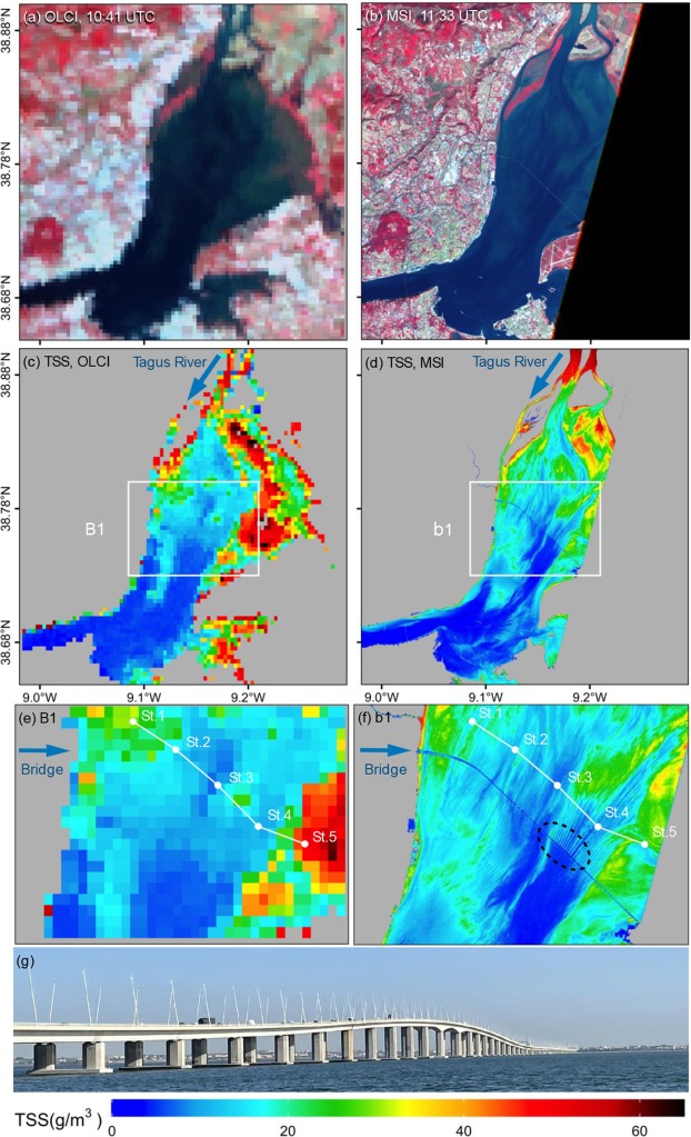
A new semi-analytical method to estimate total suspended solids (TSS) from Sentinel-2 MultiSpectral Instrument (MSI) satellite data has been developed by CERTO scientists. Extensive validation demonstrated the technique reliably estimates TSS across diverse inland and coastal waters, from clear to extremely turbid, outperforming current approaches.
Monitoring TSS is critical for managing inland and coastal aquatic ecosystems that provide key services like water provision, fisheries, and recreation to humanity. However, traditional ocean colour satellite sensors (e.g., MERIS, OLCI) lack the spatial resolution to effectively observe small water bodies.
MSI's high resolution allows TSS monitoring in small water bodies like rivers and estuaries not accessible to conventional ocean colour sensors. The detailed TSS mapping can better capture dynamics in nearshore areas and river plumes. By improving TSS estimation across inland and coastal waters with diverse optical properties, this method will allow more effective monitoring of lakes and coastal waters using a single approach.
The researchers tested the new method by applying it to more than 1000 in situ spectra collected from global inland and coastal waters, and to satellite images in the Tagus Estuary in Portugal (CERTO case study site) and Lake Kasumigaura in Japan, finding good agreement with in situ data. These diverse test cases were chosen to evaluate the method across different inland and coastal aquatic environments.
Tracking changes in suspended solids can identify pollution events and support remediation actions. Overall, this innovative technique enables more effective monitoring of suspended solids to improve water quality management in vital inland and coastal waters with satellite imagery.

TSS spatial distribution in the Tagus Estuary on 19 October 2021. (a) OLCI false colour image (b) MSI false colour image (c) TSS estimated from OLCI. (d) TSS estimated from MSI. (e)–(f) TSS maps of subareas of B1 and b1, where white dots are in situ sampling stations visited on the day of satellite overpass. (g) Photo of the Vasco da Gama bridge over the Tagus Estuary taken on 19 October 2021 during the CERTO campaign.
Jiang, D., Matsushita, B., Pahlevan, N., Gurlin, D., Fichot, C.G., Harringmeyer, J., Sent, G., Brito, A.C., Brotas, V., Werther, M., Mascarenhas, V., Blake, M., Hunter, P., Tyler, A., Spyrakos, E. 2023. Estimating the concentration of total suspended solids in inland and coastal waters from Sentinel-2 MSI: A semi-analytical approach. ISPRS Journal of Photogrammetry and Remote Sensing, 204: 362-377. doi: 10.1016/j.isprsjprs.2023.09.020